British weather has always been a national obsession, but the last 48 hours have pushed things into the territory of a low-budget disaster movie. We've just swung from the hottest day of 2026 to freezing snow and something the tabloids love to call "blood rain." It’s enough to give anyone whiplash.
If you woke up today wondering why your car looks like it’s been through a rusted car wash or why you’re reaching for a parka after a day in shirtsleeves, you’re not alone. Here is the reality behind the chaos and what it actually means for your week ahead.
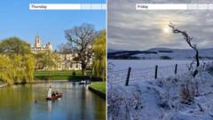
The 19C Peak and the North-South Divide
On Thursday, Northolt in West London officially clocked in at 19.2°C. For context, that’s significantly warmer than the average for early March, which usually hovers around a crisp 10°C. It wasn’t just a fluke in the capital either; Kew Gardens and other spots across the southeast were basking in high teens, making it the warmest day of the year so far.
But while Londoners were searching for their sunglasses, the north was having a completely different experience. As the warm southerly air fought to push upward, it slammed into a cold front that refused to budge. The result? Total atmospheric warfare.
When Dust Turns to Blood Rain
The most visual part of this weather tantrum has been the "blood rain." Despite the name, it’s not nearly as gothic as it sounds. It’s basically a massive plume of Saharan dust that got sucked up into the atmosphere over North Africa and hitchhiked its way across the Mediterranean on a strong jet stream.
When this dust meets a rain cloud, the water droplets latch onto the sand particles. As it falls, it leaves a tell-tale reddish or orange film on everything it touches.
- The Car Problem: If your car is covered in this stuff, don’t just wipe it off with a dry cloth. That dust is silica-based—basically fine sand—and it'll scratch your paintwork faster than a disgruntled cat.
- The Sunset Bonus: On the flip side, that same dust scattered the light beautifully on Thursday evening, giving us some of the most intense, fiery sunsets we’ve seen in years.
The Return of the Snow Bomb
The real shock came in the transition. Within hours of hitting those 19°C highs, temperatures in some regions plummeted toward zero. In parts of North Yorkshire, specifically around Wensleydale and Swaledale, the rain turned into heavy, wet snow.
This isn't just "mountain weather." Police had to assist several vehicles that got stuck as the roads transformed from damp to treacherous in a matter of minutes. We are currently seeing a 20-degree swing in less than two days, which is a massive strain on local infrastructure and, frankly, our collective sanity.
What the Met Office is Warning About Next
The immediate danger isn't just the cold—it’s the water. The Met Office has issued over 25 flood warnings. Because the ground is already saturated from a wet February, this new influx of rain (and melting snow) has nowhere to go.
If you’re looking at the charts for next week, don't pack away the winter gear. While the "blood rain" has mostly washed through, the ECMWF models are showing a potential "eight-day blizzard" scenario starting around March 13. We’re looking at a setup where cold Arctic air might dive south, potentially bringing snow as far as London and the south coast.
How to Handle the Next 48 Hours
You can't trust the thermometer right now. The "feels like" temperature is significantly lower than the actual reading because of the biting wind chill coming off the North Sea.
- Wash your car properly: Use a pressure washer to rinse the Saharan grit off before you touch the surface with a sponge.
- Check your pipes: These rapid freeze-thaw cycles are exactly what causes pipes to burst. If you have exposed outdoor taps, cover them.
- Flood watch: If you live near a river in the Midlands or the North, keep an eye on the Environment Agency’s live maps. The runoff from the recent snow is hitting the river systems today.
The UK weather isn't just "changeable" anymore; it's becoming volatile. We’re seeing more of these extreme swings where Saharan heat and Arctic chills fight for dominance right over our heads. Stay weather-aware, keep the de-icer handy, and maybe keep a rain jacket in the car even if the sun is out.
Check the latest local flood alerts on the government's official website before traveling through rural routes this evening.