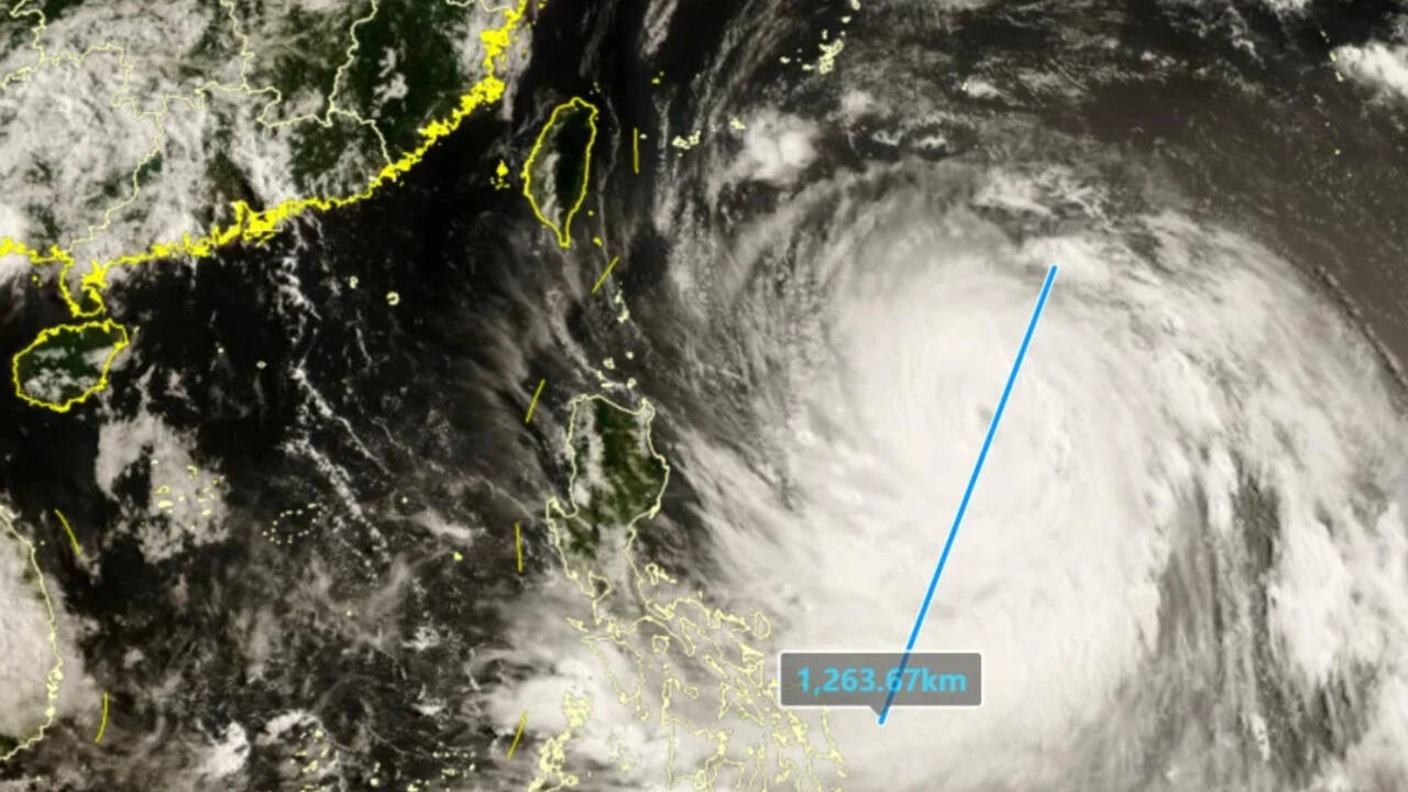
Giant storms don't care about borders. Right now, a massive atmospheric monster is churning through the Western Pacific, and it spans nearly 1,000 kilometers at its widest point. That is roughly the width of France. Typhoon Bavi is rapidly intensifying over exceptionally hot ocean waters, and it has set its sights on Taiwan, China, and Japan.
If you think this is just another routine seasonal storm, you're missing the big picture. Forecasters in Taiwan are already pointing out that Bavi is tracking to be the largest storm by physical footprint to hit the region since 1987. This isn't just about extreme wind speeds. It's about sheer scale, massive rainfall capacity, and an incredibly unfortunate path that targets areas already battered by severe weather.
The Perfect Storm Matrix
Tropical cyclones need fuel, and Bavi is drinking from a hyper-charged ocean. Right now, sea surface temperatures across the Western Pacific are averaging 2 to 3 degrees Celsius above normal. Along the immediate coastlines of China, Taiwan, and southern Japan, those anomalies climb up to 4 degrees Celsius above average.
The water temperatures are hovering between 29°C and 32°C. That is essentially an open thermal tap for a brewing storm. Because of these conditions, Bavi transformed from a disorganized tropical system into a terrifying category five equivalent powerhouse in less than 48 hours.
The timing is brutal. China is already dealing with the chaotic aftermath of Typhoon Maysak, which ripped through the southwestern Guangxi region, leaving 39 people dead and nine missing. The ground is fully saturated. River systems are already maxed out. Dropping a storm the size of Western Europe onto a region that hasn't even finished searching through wreckage is a recipe for a logistical and humanitarian crisis.
Taiwan Mounts a Massive Defense
Taiwan is taking the threat with extreme seriousness. The current trajectory shows the storm skirting the northern tip of the island before heading toward the Chinese mainland. But skirting doesn't mean escaping the damage. Because Bavi is so wide, its outer bands will hammer the island's northern mountain ranges with relentless moisture.
Local forecasters expect up to 1 meter of rain to fall in the mountains surrounding Taipei. Think about that volume of water. It triggers immediate threats of catastrophic mudslides and flash flooding in steep, high-altitude terrain.
The response on the ground has been swift:
- The defense ministry put 29,000 soldiers on active standby for immediate rescue and evacuation operations.
- Emergency management teams are pre-positioning water pumps, heavy machinery, and temporary shelters in vulnerable northern districts.
- Maritime authorities have cleared harbors, ordering fishing fleets back to port to secure hulls against violent coastal surges.
This represents Taiwan's most aggressive military and civil deployment for a tropical system since Super Typhoon Kong-rey back in 2024.
China and Japan Bracing for Massive Disruptions
As Bavi moves northwest, the threat expands exponentially. China's National Meteorological Centre projects the system will make a direct landfall in eastern Fujian province. Millions of people live along this industrial and economic corridor.
The Chinese Ministry of Emergency Management has already deployed 20,000 firefighters equipped with hundreds of specialized rescue boats to critical coastal zones. Business closures, halted rail lines, and mandatory evacuations are already being executed across low-lying coastal towns.
Meanwhile, Japan is feeling the western edge of the storm's fury. The Japan Meteorological Agency issued high-priority warnings for the Sakishima and Okinawa Islands. Bavi's heavy outer bands are lashing the archipelago with intense wind gusts and massive wave actions.
The aviation sector took a hard hit before the first drop of rain even fell. Commercial airlines, including Japan Airlines and All Nippon Airways, immediately canceled dozens of domestic flights serving Okinawa and the Amami Islands, leaving thousands of passengers stranded and disrupting critical supply chains to the outer islands.
The Reality of Hyper Scale Storms
We often fixate purely on the category number of a typhoon, looking only at the peak sustained winds near the eye. Bavi proves why that metric is deeply flawed. A compact category five storm can cause devastating localized destruction, but a massive mid-sized or giant storm like Bavi distributes severe damage across thousands of square miles.
When a storm is as wide as France, you don't need a direct hit to experience disaster. The storm surge can back up rivers hundreds of miles away from the eye. The wind field can rip down regional power grids, paralyze transport networks, and ruin vast agricultural fields simultaneously across multiple nations.
The presence of El Niño patterns is heavily driving these volatile climate dynamics. High ocean heat content means storms retain their structural integrity longer and hold significantly more precipitable water. Bavi isn't a freak anomaly. It is a terrifying blueprint of modern extreme weather.
If you are located anywhere along the eastern coast of China, northern Taiwan, or the southern islands of Japan, stop waiting to see if the track shifts. Secure your property, back up emergency power supplies, map out your local evacuation routes, and follow real-time alerts from local meteorological bureaus. The window for easy preparation is officially closed.