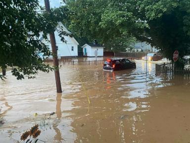
Flash flooding events in mountainous topography represent a compound system failure where meteorological intensity intersects with critical geographical vulnerabilities. When extreme rainfall events claim lives in regions such as West Virginia, public reporting frequently attributes fatalities to rain volume alone. This misdiagnoses the structural failure. Mortality in flash flood events is driven by three quantifiable factors: topographic slope amplification, soil saturation thresholds, and delayed emergency dispatch latency.
Understanding the casualty mechanics of severe weather requires deconstructing the physical processes that transform surface runoff into lethal hydrodynamic forces within short time horizons. You might also find this similar story useful: The Culture War Behind a Turkish Governor and a Pair of Cycling Shorts.
Hydrodynamic Forces and Topographic Amplification
Mountainous terrain drastically compresses the hydrograph—the time interval between precipitation input and peak riverine discharge. In flat coastal areas, rainfall distributes laterally across broad basins, extending the time to peak flood stage to several hours or days. In steep Appalachian valleys, high relief ratios convert precipitation into high-velocity channel flow within minutes.
When intense rainfall hits steep slopes, water movement accelerates according to two fundamental variables: As reported in detailed articles by TIME, the implications are worth noting.
- Gravitational Velocity Scaling: Surface runoff velocity scales directly with channel slope steepness. In steep narrow hollows, flow velocities frequently exceed 10 to 15 feet per second. At these velocities, water exerts hydrodynamic forces capable of displacing vehicles and destroying residential foundations.
- Volumetric Channeling: Dendritic drainage networks aggregate surface runoff from extensive high-elevation catchment zones into narrow valley bottoms. A localized storm dropping two inches of rain over an upper ridge line can concentrate hundreds of thousands of cubic feet of water into a single narrow stream bed.
This concentration transforms shallow channels into high-velocity torrents without warning. The structural density of mountain communities—often restricted to narrow valley bottoms along river corridors due to buildable land constraints—places human settlements directly in the high-energy flow paths of these concentrated discharge channels.
Soil Mechanics and the Pre-Saturation Trigger
Flash floods do not depend solely on single-day rainfall totals. The primary determinant of severe surface runoff is the antecedent precipitation index (API), which quantifies soil moisture levels prior to an extreme weather event.
Soils exhibit distinct infiltration capacity limits. Under dry conditions, unsaturated soil acts as a hydrologic buffer, absorbing significant rain volume through capillary action and soil porosity. However, continuous rainfall over preceding days or weeks fills soil pores, driving atmospheric moisture retention toward zero infiltration capacity.
Once soil reaches total saturation:
- Infiltration Rate Drops to Zero: The rate at which soil absorbs surface water approaches zero millimeters per hour.
- Direct Runoff Conversion: One hundred percent of subsequent rainfall is converted directly into surface runoff.
- Hydrograph Spiking: Channel discharge rates experience exponential spikes rather than linear increases, sharply reducing the time window available for evacuation.
When pre-saturated soils coincide with high-intensity convective rainfall cells, the drainage network experiences immediate structural overflow. Trees, sediment, and structural debris become entrained in the flow, forming temporary debris dams in narrow culverts and under bridges. When these informal dams rupture under hydrostatic pressure, they release surge waves that drastically increase downstream flow depth and kinetic energy, catching residents unprepared.
Structural Vulnerabilities in Infrastructure and Emergency Logistics
The high mortality rates associated with sudden flooding stem directly from specific operational bottlenecks in rural emergency infrastructure. Civil defense protocols in isolated terrain face distinct physical constraints that increase casualty risks.
Communication Sclerosis and Signal Occlusion
Topographic features physically block high-frequency radio and cellular signals. In deep valleys, emergency broadcast signals often fail to reach populations located in the lowest elevation zones—the exact areas at highest risk. When power grid nodes fail due to early storm damage, redundant battery systems at cellular towers deplete quickly, severing real-time communication channels between emergency dispatch centers and rural populations.
Roadway Disruption and Access Blockades
Rural transportation networks in topographically complex regions rely heavily on single-artery primary roads that follow stream banks. This creates catastrophic single-point failure risks:
- Bank Undermining: High-velocity water scours the toe of roadway embankments, triggering structural pavement collapse.
- Culvert Failure: Undersized drainage infrastructure clogs with vegetative debris, forcing water over road surfaces and stripping asphalt.
- Bridge Submersion: Low-water bridges become impassable early in the flood event, isolating entire communities and preventing emergency vehicle access.
When emergency responders cannot navigate blocked access corridors, life-safety operations shift from proactive evacuation to reactive rescue under active hazard conditions.
Strategic Mitigation Directives for High-Risk Drainage Corridors
Mitigating casualties from short-duration flooding requires shifting from passive weather alerts to active, automated infrastructure management. Standard regional flood watches provide broad geographical warnings that fail to drive immediate individual evacuation actions in high-risk zones.
Regional authorities and civil engineers must implement four specific technical interventions:
- Automated Stage-Discharge Sensors: Deploy low-power micro-radar water level sensors along upper-catchment tributaries to detect early discharge surges miles upstream of population centers.
- Hardened Mesh Telemetry: Build redundant, low-frequency radio relay networks along ridgelines that operate independently of commercial power and cellular infrastructure to ensure warning delivery.
- Culvert Capacity Rescaling: Replace traditional circular culverts with wide-box culverts sized to accommodate 100-year flow rates along with significant woody debris volume.
- Zoning and Structural Relocation Programs: Establish strict development prohibitions within primary high-energy channels, combined with buyout incentives for residential structures built in active floodways.
Systemic survival rates depend on reducing dispatch latency and providing automated, hyper-local hazard warnings before hydrologic thresholds cross into destructive channel flow.


