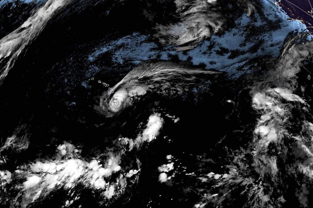
Tropical Storm Lala is bearing down on Hawaii with sustained winds of 70 mph, threatening the Big Island with potential hurricane-force impacts, catastrophic rainfall totals reaching up to 25 inches, and a rare hurricane warning that underscores the severe vulnerability of an island chain unaccustomed to direct landfalls.
Most standard storm reports stop at the wind speeds and projected rainfall maps. They treat the system as a routine meteorological event occurring in a tropical paradise. That surface-level coverage misses the structural danger. Hawaii sits in a unique oceanic and geographic corridor where rare storm tracks intersect with fragile infrastructure, rugged volcanic topography, and a stark socioeconomic divide between modern resort areas and off-the-grid communities. Understanding what happens when a system like Lala approaches requires looking past the simple category ratings and examining the physics of island-mountain meteorology.
The Topographic Trap
The Big Island is not a flat coastal plain. It is dominated massive volcanic peaks—Mauna Loa and Mauna Kea—that rise nearly 14,000 feet into the atmosphere. This extreme elevation changes everything about how a tropical storm behaves.
When a weather system approaches these towering slopes, standard wind dynamics break down. Meteorologists frequently note that wind speeds on mountain ridges and steep slopes can surge up to thirty percent stronger than the ambient near-surface winds measured by offshore buoys or satellite scatterometers. A storm packing 70 mph winds at sea level transforms into a destructive engine when forced upward and compressed against volcanic terrain.
Orographic lift squeezes moisture out of the atmosphere with merciless efficiency. As warm, saturated air driven by Lala collides with the eastern and southern flanks of the Big Island, it rises rapidly, cools, and dumps torrential rain. Forecasts projecting up to 25 inches of rain are not mere statistical outliers; they are a mechanical certainty given the moisture content of the air mass and the sheer vertical barrier blocking its path.
This creates an immediate hazard for flash flooding and deep-seated landslides. The basaltic rock and weathered volcanic ash soils of the island can only absorb a finite amount of water before losing structural cohesion. Once saturation occurs, gravity takes over. Entire hillsides can give way without warning, sweeping away roads, bridges, and structures in its path.
The Infrastructure Vulnerability Gap
Emergency management in the Hawaiian Islands faces a logistical nightmare born of geography and history. Unlike the continental United States, where highway grids offer multiple evacuation routes and redundant loops, the Big Island relies on a sparse ring road system. If a single stretch of coastal highway washes out due to high surf or storm surge, or if a major interior pass is blocked by a landslide, entire communities can be instantly isolated.
Furthermore, the demographic reality of the island complicates evacuation mandates. Thousands of residents live off the grid in remote subdivisions, forest settlements, or steep agricultural valleys. Many rely on catchment water systems, solar setups, and improvised housing structures that are poorly suited to withstand prolonged tropical storm force winds.
When state officials urge residents to shelter in place or evacuate early, they are running up against a culture of self-reliance forged by rural living. Convincing a coffee farmer in Kona or a resident in a remote Puna subdivision to abandon an off-grid homestead requires overcoming deep-seated skepticism toward government mandates. Yet, the physical risk is absolute. Winds extending outward for more than 200 miles mean that the hazard zone encompasses far more than just the immediate eye of the storm.
The Historical Precedent and Climate Realities
Direct hurricane landfalls in Hawaii are historically rare, which breeds a dangerous sense of complacency among the general public. The last hurricane to inflict catastrophic damage of historic proportions was Iniki in 1992, while true hurricane landfalls on the Big Island are generational events. Historical research into nineteenth-century records points to a significant storm striking the northeastern coast in 1871, leaving modern generations with no living memory of a direct strike on the island.
This absence of recent trauma alters risk perception. Human beings judge risk based on experience rather than statistical probability. Because decades have passed without a catastrophic wind event, building codes, commercial preparations, and individual readiness often lag behind what is necessary for a direct encounter with a hurricane-strength core.
At the same time, the broader oceanic context reveals why storms like Lala are forming and tracking into the Central Pacific. Elevated sea surface temperatures driven by active climate phases provide the thermal fuel necessary for tropical systems to rapidly intensify in regions that historically discouraged storm maintenance. Warmer water acts as an accelerator, turning marginal tropical depressions into formidable threats over a matter of hours.
Emergency Preparedness Realities
The immediate response phase requires precise execution from state and local agencies. Shelters open across the affected counties, National Guard units stage equipment for rapid deployment, and public utilities preposition repair crews to tackle inevitable grid failures. However, the institutional response is only half the equation.
The real test of resilience happens at the individual level long before the first bands of rain hit the coast. Clearing property of loose debris, protecting windows, securing auxiliary power sources, and maintaining an emergency stockpile of food and fresh water are basic steps that determine whether a household survives a multi-day power outage unscathed.
As Tropical Storm Lala sweeps across the region and brushes the island chain, the physical scars left behind will test the long-term endurance of local agricultural sectors, tourism infrastructure, and municipal budgets. Recovery is rarely swift when geography makes supply chains inherently fragile.
The immediate threat will eventually pass into the western Pacific, leaving behind swollen rivers, rearranged coastlines, and a sobering reminder of how quickly paradise can be reshaped by the raw atmospheric power of an ocean storm.


