Structural Vulnerabilities in High Altitude Crisis Response
High-altitude natural disasters expose the systemic fragility of emergency management frameworks operating in extreme topography. When an avalanche triggers flash floods in regions like the Himalayas, the resulting crisis is rarely a pure function of meteorological anomaly. Instead, it represents the intersection of severe environmental volatility, compressed logistics windows, and delayed multi-agency coordination. Examining events where foreign nationals and local populations go missing following mass displacement events requires moving beyond standard incident reporting. Analysts must deconstruct the operational architecture of search and rescue operations, the economic drivers of high-risk trekking during shoulder seasons, and the communication bottlenecks that impede immediate tactical deployment.
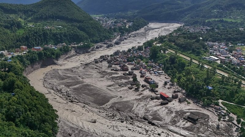
The baseline mechanism of such disasters relies on a compounding cascade of physical events. An initial mass wasting event, such as an avalanche, dumps millions of tons of snow and debris into high-altitude river basins or glacial lakes. This sudden displacement creates an immediate hydraulic surge, breaching natural moraine dams or overwhelming narrow gorges. The downstream velocity of this debris flow multiplies exponentially, transforming a localized snow slide into a regional flash flood. For infrastructure and human settlements situated in valley bottoms, the time delta between initial trigger and impact is measured in minutes, rendering conventional evacuation warnings ineffective.
Search and rescue operations in these environments operate under severe operational constraints. Altitude sickness, volatile weather shifts that ground rotary-wing aircraft, and rugged terrain limit ground team mobility. When an Australian national or any other traveler goes missing in such chaotic scenarios, tracking relies on sparse telemetry, eyewitness accounts that are often contradictory, and the slow deployment of specialized mountain rescue units. The friction of distance and bureaucratic delay between local police, federal disaster management authorities, and international consular offices creates critical gaps in the initial golden seventy-two hours of a search window.
The Economic and Logistical Cost Function of Adventure Tourism
The expansion of commercial trekking and expedition tourism in remote mountain ranges introduces a distinct risk matrix. Local economies depend heavily on the influx of foreign capital, creating an implicit incentive to maintain open access routes even as environmental indicators suggest rising hazard levels. Risk mitigation protocols often fail because they rely on voluntary compliance by independent travelers rather than enforceable regulatory thresholds.
Risk exposure correlates directly with several structural variables. First, temporal scheduling plays a definitive role. Trekking outside peak stabilization windows increases exposure to unseasonal weather patterns driven by shifting climatic baselines. Second, communication infrastructure density dictates response efficacy. In deep river valleys, satellite connectivity is sparse, and cellular networks are nonexistent. Consequently, distress signals are delayed until survivors reach designated relay points, skewing the timeline for first responders. Third, the fragmentation of local guiding agencies leads to variable safety standards. While elite expedition operators maintain redundant communication arrays and private evacuation insurance, independent or budget-oriented trekkers frequently operate without real-time monitoring.
Economic pressures also influence regional disaster preparedness. Municipal authorities in high-risk zones face capital allocation constraints. Investing in comprehensive early warning sensor networks along remote glacial riverbeds competes with basic infrastructure maintenance. As a result, disaster response in these sectors remains reactive rather than predictive. The financial burden is ultimately transferred to international insurance pools, foreign governments providing consular rescue coordination, and local communities absorbing the long-term contraction of tourism revenue following a high-profile tragedy.
Operational Failures in Multi-Agency Crisis Management
When cascading environmental events overwhelm local response capacities, coordination friction emerges as the primary point of failure. Effective crisis management requires the seamless integration of distinct operational units: military search and rescue teams, medical triage units, local law enforcement, and diplomatic liaisons. In practice, jurisdictional overlaps and incompatible communication protocols generate severe operational latency.
Information asymmetry exacerbates this latency. Initial media reports frequently distort casualty numbers and missing persons data, forcing diplomatic missions to divert resources toward verifying unconfirmed accounts rather than supporting active rescue operations. Consular staff managing the welfare of missing foreign nationals must navigate opaque local administrative channels, where data sharing between regional police posts and central government ministries is slow and manual.
Resource allocation follows a triage hierarchy that often disadvantages foreign independent travelers. Search assets are deployed first to dense population centers or large commercial groups where the probability of high-impact rescue is maximized. Isolated hikers or small parties missing in remote sectors receive marginal resource allocation during the critical initial phase. This resource starvation reflects a utilitarian calculus under extreme scarcity, but it underscores the structural inadequacy of current rescue frameworks when applied to dispersed populations.
Strategic Reform and Predictive Risk Architecture
Mitigating the recurrence of mass casualty events in high-altitude adventure zones requires a transition from reactive rescue models to predictive risk architecture. This transition depends on three structural interventions.
First, mandatory digital tracking must be integrated into regional entry permits. Requiring trekkers to carry standardized, low-power satellite transponders eliminates the data blackout that characterizes the first twenty-four hours of a disappearance. Centralized monitoring stations can track real-time positioning against known hazard zones, triggering automated alerts when an asset remains stationary within a high-risk corridor or deviates from registered itineraries.
Second, deployment protocols for emergency response must be decentralized. Relying on centralized military clearance for rotary-wing deployment wastes critical minutes. Establishing forward-operating rescue pods stocked with medical supplies, autonomous drones, and trained canine units in high-frequency incident zones reduces response time from days to hours.
Third, regulatory enforcement of seasonal closures must be decoupled from local economic incentives. Independent scientific bodies should dictate access permissions based on real-time geotechnical assessments of glacial lakes and avalanche risk indexes, overriding commercial pressures to keep routes open.
The systemic management of high-altitude disasters cannot eliminate environmental volatility. However, by replacing ad-hoc emergency responses with standardized telemetry, localized tactical readiness, and data-driven access controls, the duration of uncertainty for missing persons and the severity of regional casualties can be systematically reduced.


